The best way to get weather information over satellite is to download GRIB files. Wikipedia defines GRIBS this way:
GRIB (Gridded Binary) General Regularly-distributed Information in Binary form is a concise data format commonly used in meteorology to store historical and forecast weather data.
Concise is the important part. You’ll be downloading these files over satellite, so they need to be small. Then you can view them with GRIB viewer software that turns those little spits of data into the oceanographic and atmospheric forecasts that you need.
The very first step in order to get GRIB weather files over satellite is having a satellite system. Which one is right for you depends a lot on your individual needs. We recommend checking out the Blue Water Cruising Communication Guide for a great overview of the different systems.
Regardless of which satellite system you get, you should be able to download GRIB files. Sending data over a satellite link requires stronger signal than making a voice call. For most handheld satellite systems, having an external antenna for that phone is strongly recommended for downloading GRIB files or emails.
Other systems, like BGAN, Fleetbroadband, or Iridium Pilot all have the power and capability to very quickly download GRIB files.
Once you have your satellite system and external antenna if you need it, you'll need to choose an airtime plan.
Here is a blog post on prepaid vs postpaid airtime to help with that choice.
Now, let's get to the GRIB files.
Part II: Ways to Get GRIB Weather Files

There are free services out there that send GRIB files to your email address (we have one such service, you can read more about it here). These are simple wind GRIB files and the email request to the GRIB service can be quite complicated to configure. While there is no charge for the files themselves, note that they require airtime to download and connection costs to send/receive the GRIB requests. XGate service can reduce the airtime by a factor of 15-20 times on average. For even better reduction of airtime, consider a dedicated service like WeatherNet.
 Option 2 - WeatherNet Weather On Demand Service (Mac/Windows)
WeatherNet is a GRIB file download service that has a very easy to use interface and an incredibly robust library of weather information to choose from. You basically draw a square of your location on a map, click on the types of weather files you want to download, and hit the "submit" button. WeatherNet will retrieve those files and return them to you in a single connection. WeatherNet costs $99 a year for the service. Additionally, you need to purchase prepaid data cards (I would recommend the one for $75) that you deduct your GRIB files from.
Here is a blog post looking at the price difference between downloading free GRIB files and using WeatherNet.
There are programs out there that fetch GRIB files and load them on your iOS or Android mobile device. There are options for iOS like WeatherTrack and iNavX that are "XGate Aware" meaning that they integrate with XGate functionality to decrease airtime costs.
Here is a blog post on 7 ways to get GRIB files on iPad or Android.
This is NOT RECOMMENDED! Keep in mind that over a handheld satellite phone, it typically takes around 70 minutes to open up a single web-page. (Even running compression it would still take around 25 minutes to open up a single page).
Finding the file you're looking for and downloading it is simply too expensive and time-consuming.
Even over a broadband device, you would be looking at airtime charges in the MB range ($7-$21, depending on your plan and provider) vs a couple of cents for downloading a GRIB file via email.
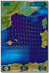
.png) GRIB Viewer
GRIB ViewerNo matter where you get your GRIB files from, you will need a software program called a GRIB viewer in order to decode the GRIB data and display the visual weather data.
For Windows and Mac, we sell an excellent one called GRIB Explorer.
For iOS devices like iPhone and iPad, many GRIB retrieval services like GRIB Explorer+, WeatherTrack, and iNavX all have built-in GRIB viewers - you don't need to download additional software in order to view GRIB files when using those programs.
For Android, there are many different options. We recommend looking in the Google Play store for "GRIB viewer" and test any free versions before committing to purchase.
We'd be happy to recommend the perfect satellite communications equipment and airtime for your needs. You can get a free satellite communications consultation or just give us a ring at +1.877.379.8723 (US) or +1.865.379.8723 (Intl) - we're here to help!